The Azores archipelago consists of nine inhabited islands. Each of them can and should be visited, because they are all so different. It is unlikely to be possible in one trip, but in two or three it is easy. Let's find out what each island is like and choose the most interesting ones for the first trip.
Personal experience... So far I have visited only two islands: San Miguel and Floriche. But considering that I'm just obsessed with the Azores and all of Macaronesia, I know a lot about those islands where I have not yet been. In the future, I'm going to visit all of them, so for my own needs I studied all the islands in detail in order to understand why each of them is remarkable and interesting. There is nothing to lose my knowledge, I decided and prepared this review. I tried to make it as clear as possible, so I illustrated it richly. I hope the review came out useful, interesting and inspiring.
Azores on world map
The Azores are divided into three groups (the map below shows this division well). The largest island is São Miguel, where the capital is located - Ponta Delgada. And the highest point of the archipelago and all of Portugal is the Pico volcano on the island of the same name (2351 m).
Grouping of the Azores and content of the review:
San Miguel
This is the main island of the archipelago, here is its capital and largest city - Ponta Delgada.
The island is quite large, there is where to ride and what to see. We spent six days here and never got bored. We rode in a car around the island, visited volcanic lakes and gorgeous viewing platforms, swam in mineral springs and on many ocean beaches, walked in parks, admired the lush hydrangea flowers, visited a tea plantation, wandered through the old streets of the capital and looked at several more villages on the island ... Here you can also go surfing, watch whales and taste the Azorean signature dish - Cozido das Furnas - meat cooked in the heat of the volcano.
Of all the Azores, it is to San Miguel that the most tourists come, because it is easy to get here from the continent, there is all the infrastructure, many hotels and housing for rent, large supermarkets and so on.
The island is called Green, which is absolutely deserved: there are more than enough greenery, flowers, forests, meadows and beautiful parks.
The island is beautiful and interesting - definitely worth a visit.
- Length - 64 km, width - 14 km.
- The area is 746.8 km².
- The highest point is 1103 meters.
- Population - 137,856 people (2011).


Santa maria
The southernmost and sunniest Azores island is small in size. It is primarily known for its white sand beaches. Well, as white ... rather yellow, but in comparison with the black volcanic sand on other islands, this sand can be considered white. Here you can look at marine fossils in basalt rocks, as well as visit the church, where Christopher Columbus went to listen to Mass on the way from America.
- The maximum diagonal length is 15.5 km.
- The area is 97.18 km².
- The highest point is 587 m.
- Population - 5552 people. (2011).
Santa Maria is the oldest island in the archipelago (it is more than 8 million years old) and the only one where volcanic activity is no longer observed today. It became the first Azores island discovered by the Portuguese. The island is also called Yellow.


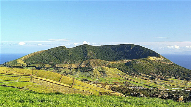
Graciosa
Small island in the central group. It is famous for its deep cave in the volcano's caldera, at the bottom of which there are fumaroles and a lake with cold water. On the island, you can relax and heal at the local spa.
- The island is 12.5 km long and 8.5 km wide.
- The area is 61 km².
- The highest point is Mount Caldeira (404 m).
- Population - 4391 people (2011).
Instead of a thousand words, videos and photos will tell you about the island. Look!
Fly over the island of Graciosa by drone and admire its beauties:
Go down to the main attraction of the island - the huge sulfur grotto Furna Do Enxofre: